
|

Since 1856, innovation has been a driving force at Rand McNally. The company is leading the way with products and services for leisure and business travel, commercial trucking, education and reference.
2004 - Rand adds Perly' s, maker of street maps for Toronto, Ontario and surrounding areas. They were assimiliated into Rand McNally Canada.
 2003 - The 2004 Large Scale Motor Carriers' Road Atlas launches, featuring maps that are 32% larger than standard Motor Carriers' Road Atlas maps and offer nonglare, water-resistant and tear-resistant pages. Also, the company releases Mobile Travel Tools, a full-color, richly rendered maps-and-directions application for wireless phones. 2003 - The 2004 Large Scale Motor Carriers' Road Atlas launches, featuring maps that are 32% larger than standard Motor Carriers' Road Atlas maps and offer nonglare, water-resistant and tear-resistant pages. Also, the company releases Mobile Travel Tools, a full-color, richly rendered maps-and-directions application for wireless phones.
2002 - Rand McNally-TDM launches trucking.randmcnally.com and enhances its product line to provide even better solutions for the commercial trucking industry.
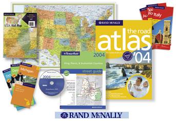
2000 - The best-selling Road Atlas line is given a major overhaul in its design and features for the 2001 editions, giving the atlases a bold new look and new additions including Best of the Road and Express Access Codes. The Road Atlas Expansion Card is released, putting the Road Atlas on Palm OS handhelds.
2000 - Rand McNally revamps their website with personalized trip planning and an enhanced Travel Store with more than 4,500 products. Also, Rand McNally becomes the primary North American distributor for National Geographic Maps.
1999 - Rand McNally acquires Thomas Bros. Maps, bringing the two leading map publishers together. Rand McNally' s website is enhanced with address-to-address driving directions, downloadable maps, and a revamped Travel Store with more than 4,500 products. Rand McNally-TDM introduces IntelliRoute, the most advanced trucking database in North America.
1998 - The Rand McNally Road Atlas Deluxe Edition is introduced, adding shaded terrain relief to the maps for the first time.
1997 - A private investment firm purchases Rand McNally from the McNally family. The Rand McNally Travel Store, the world's most comprehensive online travel store, is launched on the company website.
1996 - Building on the success of TripMaker, the company introduces StreetFinderstreet navigation software. The same year, randmcnally.com is launched, offering up-to-date information on road construction and weather, online reservations, and many other services. Also, Rand McNally acquires the assets of map publisher H. M. Gousha Company.
1994 - Rand McNally introduces TripMaker travel planning software, which wins awards.
1993 - Rand McNally acquires Allmaps Canada Limited, a leading producer of consumer and business-to-business maps and atlases. This company will become Rand McNally Canada. Also this year, the Road Atlas is the first Rand McNally product created using an all-digital method. The new technology produces the same high-quality cartography while reducing production costs.
1989 - Rand McNally expands its Map & Travel Store retail operations.
1988 - Champion Map - Rand continued to use their facilities in Dayton Beach until 2001. All of the Champion Map products disappear but in 2007 Rand began to use the brand on the street maps for selected small markets or communities.
1986 - Thomas Bros. Maps implements digital mapping to create its products.
1984 - Rand McNally acquires the assets of Denoyer-Geppert Company, a leading school map and globe publisher.
1980 - Rand McNally creates the Transportation Data Management (TDM) division to focus on commercial routing. TDM devises standard mileage reporting with "Household Good Miles." Also this year, Thomas Bros. Maps relocates to Irvine, California.
1974 - Andrew McNally IV succeeds his father as President.
1969 - The first edition of The International Atlas is published by a historic cooperative project by an international group of mapmaking firms led by Rand McNally. The atlas includes maps utilizing the Robinson Projection, created for Rand McNally by renowned cartography professor Arthur H. Robinson.
1960 - The first full-color Rand McNally Road Atlas premieres.
1954 - Rand McNally revolutionizes the industry by becoming the first commercial mapmaker to adopt the scribing process to make maps.
1952 - The company moves its corporate headquarters to Skokie, Illinois.
1948 - Andrew McNally III becomes company president.
1937 - Rand McNally opens its first Map & Travel Store, in New York City.
1933 - Andrew McNally II becomes company president. Rand McNally inspires the stage name of "Sally Rand," the famous fan dancer and star of the 1933 Chicago World's Fair.
1924 - The Rand McNally Auto Chum is published; it is the first edition of what will become the best-selling Rand McNally Road Atlas.
1922 - Rand McNally publishes the first edition of Goode's World Atlas (named after its first editor, Dr. J. Paul Goode). It becomes the standard geography text for high schools and colleges and continues today.
1917 - Rand McNally introduces the concept of identifying roads by number, debuting on a road map of Illinois. State and federal authorities subsequently adopt this system and it is still used today.
1915 - Thomas Bros. Maps is founded in Oakland, California. Their distinctive page-and-grid system will help to make Thomas Guides the "bible" for drivers on the West Coast.
1910 - Rand McNally assumes publication from G.S. Chapin of the Photo-Auto Guides, which combine maps and photos with overlaid arrows to indicate correct turns. Andrew McNally II personally takes the pictures for the Chicago-to-Milwaukee edition while on his honeymoon!
1904 - Rand McNally's first automobile road map, New Automobile Road Map of New York City & Vicinity, is published.
1899 - William Rand leaves the company to pursue other interests. Andrew McNally becomes President and his family runs the business for the next century.
1880 - The company begins producing maps and globes for schools, and publishes its first world atlas.
1876 - Rand McNally's Business Atlas debuts, later renamed the Commercial Atlas & Marketing Guide. It is still produced today.
1873 - Rand McNally is incorporated with William Rand as president and Andrew McNally as vice president.
1872 - The first Rand McNally maps are published. Rand McNally uses a new wax engraving method, which significantly reduces the cost of printing maps.
1871 - During the great Chicago Fire, William Rand saves the company by burying two printing machines in the sand!
1869 - The first railroad guide, the Western Railway Guide, is published.
1864 - Andrew McNally and William Rand begin their partnership. Together they took over first the management, and then the ownership, of the Chicago Tribune's job printing shop to form Rand McNally & Company. The company prints tickets and timetables to serve the railroads of Chicago, which is the nation's premier railroad hub.
1856 - William Rand opens a small printing shop in Chicago's Loop, forming the precursor of Rand McNally.
What began as a small ticket printing company has grown into a diverse industry leader in mapping and navigation. Rand McNally continues to move forward with a spirit of innovation that is all about bringing the best products and services to our customers.
*Information and dates provided by the Rand McNally Company.
|
| |
|